Approximately 30% of global carbon dioxide (CO₂) emissions are removed by terrestrial vegetation through photosynthesis. Researchers affiliated with UNIST have unveiled an innovative artificial intelligence (AI) analysis technique that predicts this CO₂ uptake with high temporal resolution. This advancement is expected to significantly aid climate change mitigation efforts and the development of carbon-neutral policies.
Led by Professor Jungho Im from the Department of Earth Environmental Urban Construction Engineering at UNIST, the research team announced the development of an AI model capable of estimating daily gross primary production (GPP) at hourly intervals by utilizing high-frequency data from geostationary weather satellites.
GPP is a key indicator representing the amount of carbon actively absorbed by plants during photosynthesis, serving as a crucial metric for quantifying ecosystem carbon sequestration.
The newly developed model leverages 10-minute interval observations from the Himawari-8 geostationary satellite to predict GPP with high temporal accuracy. First author Sejeong Bae explained, “Unlike polar-orbiting satellites, which typically observe a given location only 1 to 4 times per day, our model benefits from more frequent data collection, enabling precise estimation of diurnal changes in photosynthesis.”
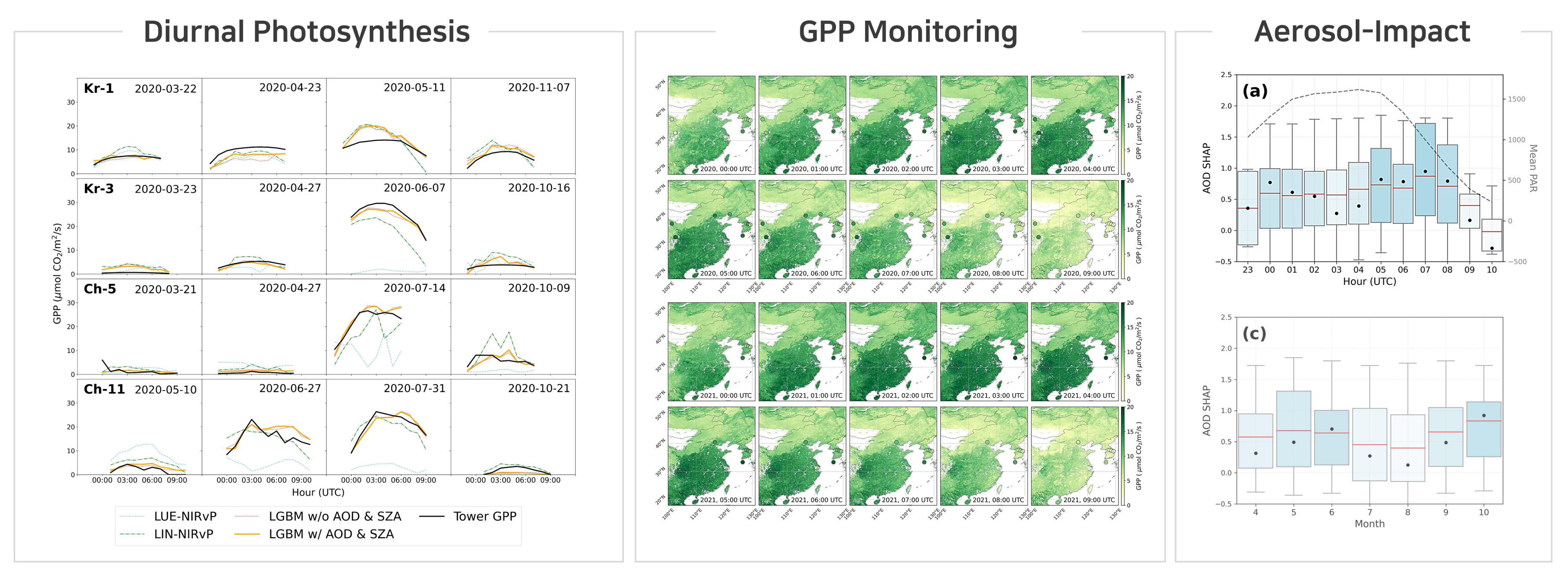 Figure 1. AI-Based Daily Photosynthesis Monitoring and Analysis of the Impact of Fine Dust
The model incorporates various meteorological data, including Aerosol Optical Depth (AOD)—a satellite-derived indicator reflecting the concentration of particulate matter such as fine dust. AOD influences the amount and quality of sunlight reaching the surface by absorbing or scattering solar radiation, thereby affecting photosynthetic activity.
To interpret how the model makes predictions, the researchers employed SHapley Additive exPlanations (SHAP), an explainable AI technique. Results revealed that AOD is the most influential factor during morning and evening hours when the solar angle is low. This finding aligns with the understanding that lower solar elevation increases the proportion of scattered light, making vegetation’s photosynthetic response more sensitive to atmospheric aerosols.
Professor Im commented, “Our approach can estimate the spatial and temporal dynamics of carbon absorption over East Asia at a 2 km resolution across 24 hours, making it a valuable tool for ecosystem carbon flux analysis, vegetation monitoring, and light environment-based carbon modeling.”
Their findings have been published in Remote Sensing of Environment (IF: 11.1), one of the leading international journals in remote sensing and environmental sciences, on June 1, 2025. The research was supported by the Korea Environment Industry and Technology Institute (KEITI) under the Ministry of Environment, as well as the Korean Agency for Infrastructure Technology Advancement (KAIA) through the Ministry of Land, Infrastructure and Transport (MOLIT).
Journal Reference
Sejeong Bae, Bokyung Son, Taejun Sung, et al., “Advancing hourly gross primary productivity mapping over East Asia using Himawari-8 AHI and artificial intelligence: Unveiling the impact of aerosol-induced radiation dynamics,” Remote Sens. Environ., (2025).


