An international team of researchers, affiliated with UNIST has unveiled a novel technology that can be used to monitor near real-time drought conditions. They have achieved this by improving the accuracy of satellite-based soil moisture estimates and processing vast amounts of satellite imagery rapidly and accurately.
Published in the December 2020 issue of Remote Sensing of Environment, this breakthrough has been carried out by Professor Myong-In Lee and Dr. Eunkyo Seo from the Department of Urban and Environmental Engineering at UNIST, in collaboration with NASA Goddard Spaceflight Center. Their findings are expected to be of great help for crop yield prediction and proactive fire prevention and management for large-scale forest fires.
In order to anticipate and proactively prepare for droughts, we need a technology that can provide near-real-time monitoring of drought severity (soil moisture scarcity levels). The latest satellites in the United States and Europe use microwave wavelengths for soil moisture measurements at depths of 5cm. However, its use has been limited due to temporal and spatial constraints on soil moisture observations. This is because the microwave-length radio waves used for such observation cannot reach the root zone layer, a penetration depth up to several tens of centimeters, which is essential for plant growth. Besides, the satellite rotates around the Earth nearly from pole to pole, leading to large observing gaps.
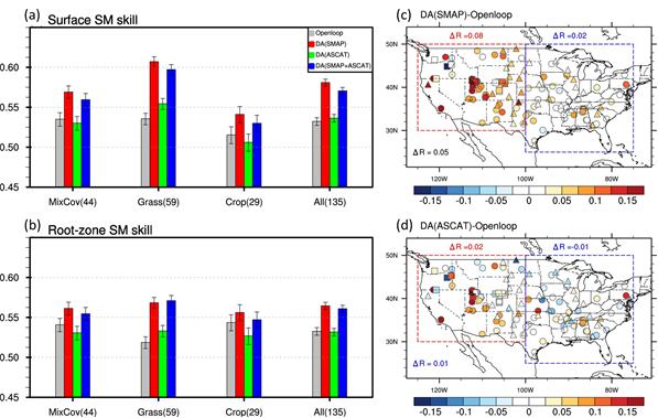
In the study, the research team developed a data assimilation system to merge satellite soil moisture retrievals into the Joint U.K. Land Environment Simulator (JULES) land surface model (LSM) using the Local Ensemble Transform Kalman Filter (LETKF). The system, according to the research team, assimilates microwave soil moisture retrievals from the Soil Moisture Active Passive (SMAP) radiometer and the Advanced Scatterometer (ASCAT) after bias correction based on cumulative distribution function fitting.

Skill of soil moisture estimates from data assimilation experiments.
The research team improved the accuracy of soil moisture estimates, using the data assimilation method that combines the soil moisture information from diverse satellite observations with the advantages of LSMs. The LSM simulation has the advantage of providing accurate and timely information on surface soil moisture, including the root-zone layer, by taking into account variables, such as precipitation, radiant heat, surface temperature, and wind. For this reason, the soil moisture assimilation estimates provide more realistic land surface information than model-only simulations, suggesting the advantage of using satellite soil moisture retrievals in the current drought monitoring system.
The findings of this research have been published in the December 2020 issue of Remote Sensing of Environment, a top publication in the field of remote sensing. This study has been supported by the Korea Meteorological Administration (KMA) and the Korea Meteorological Institute (KMI).
Journal Reference
Eunkyo Seo, Myong-In Lee, and Rolf H. Reichl, “Assimilation of SMAP and ASCAT soil moisture retrievals into the JULES land surface model using the Local Ensemble Transform Kalman Filter,” Remote Sensing Environment, (2020).


